
BlueCap survey projects
Plan, review and deliver your BlueCap survey in one workspace
Bring your survey area, terrain requirements and required results together with BlueCap. Review the plan and proposal before field work begins.
Request project accessPortal access has no software subscription fee and is provided for BlueCap service projects. Survey services are quoted separately. Create an account, verify your email, then wait for BlueCap review.
From Project Basics to controlled data delivery
- 1
Basics
Confirm the client, survey purpose, location, schedule and practical site support.
- 2
Map
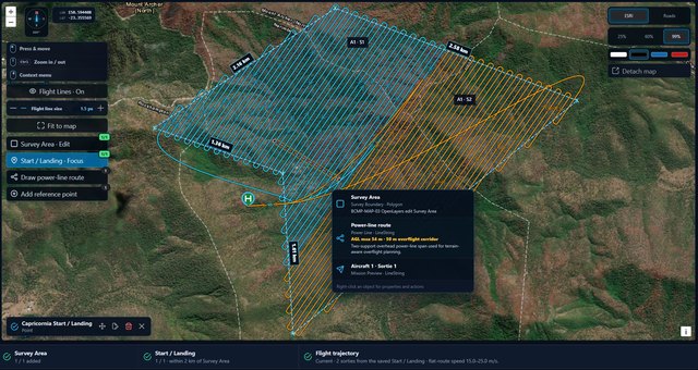
Define the survey area, shared start/landing point, operating constraints and complete 2D route.
- 3
3D Flight Simulation
Review terrain and sensor clearance against the planned horizontal route.
- 4
Quote
Review the proposal, assumptions and commercial scope with BlueCap.
- 5
Flight
Coordinate approved field work with the assigned operational team. Public access does not dispatch aircraft or export flight commands.
- 6
Deliveries
Review quality evidence and the agreed survey results through the project’s controlled delivery workflow.
Terrain-aware planning
The 2D Map calculates the complete horizontal route, including survey legs, turns, transits, returns and Sortie boundaries. The 3D preview preserves that route and adds terrain, aircraft dynamics and suspended-sensor clearance modelling. BlueCap reviews terrain suitability and the available elevation data for each project. Simulation is a planning aid; aviation approval and operational checks remain separate.
A proposal you can review with BlueCap
Review the agreed scope, planned days, equipment, travel, GST and delivery assumptions with BlueCap. A released Quote requires the appropriate human review. This public demonstration contains no client prices, documents or commitments.
One specialist workspace across multiple client programs
An Agent is the authorised geophysicist or project specialist working with assigned clients. Each client’s Projects, Quotes and discussions stay within their controlled access context. BlueCap works with the Agent through that relationship.
BlueCap survey services
BlueCap drone magnetic survey
Magnetic survey scope, terrain requirements and interpretation-ready results.
Service details: BlueCap drone magnetic surveyBlueCap LiDAR mapping
Terrain, coverage and point-cloud deliverable requirements.
Service details: BlueCap LiDAR mappingDrone radiometric survey
Survey design and agreed radioelement mapping products.
Service details: Drone radiometric survey